Authors: Almagro M1, Abrantes N2
Reviewers: Keizer JJ2
Measurement unit: Mg ha-1 y-1; Measurement scale: plot; Equipment costs: €€-€€€; Running costs: €€; Installation effort: medium; Maintenance effort: medium (frequent recording); Knowledge need: medium; Measurement mode: manual
Soil erosion can be defined as a three-phase process that consists of (i) the detachment of individual soil particles from the soil mass; (ii) their subsequent transport by an erosive agent; and, ultimately, (iii) their deposition when the erosive agent lacks sufficient energy for further transport (Morgan, 2005). In the case of soil erosion by water – the focus of this protocol – rain-splash as well as water running over the soil surface detach and then move the detached particles. Rain-splash is typically the most important detaching agent, while running water tends to be the principal transporting agent. The transport of soil particles resulting from the direct impact of falling raindrops is designated as rain-splash erosion, while the transport of soil particles by running water is commonly divided into inter-rill and rill erosion. Inter-rill erosion refers to water running as a shallow sheet (“overland flow”) and removing a relatively uniform thickness of soil, whereas rill erosion refers to water running as a concentrated flow and removing soil by “gouging out” channels of increasing depth and/or width. In turn, rill erosion is generally divided into rill and gully erosion depending on channel dimensions.
Under natural stable conditions, soil systems are considered to be under steady-state conditions, as the loss of soil material by erosion from a given area (i.e. the loss of soil, its redistribution over the landscape, and its export to river systems) is approximately balanced by the formation of soil as a result of weathering (Montgomery, 2007). However, anthropogenic activities such as intensive agriculture, deforestation, urbanisation, and road construction, have increased by 10–40 times the rate at which erosion is occurring globally, causing both on-site and off-site environmental problems (Verheijen et al., 2009). On-site impacts include the loss of carbon and nutrients such as nitrogen and phosphorus from the topsoil through soil water erosion, reducing soil fertility and plant productivity, as well as threatening key soil functions, ultimately causing land degradation and desertification, as recognised by the European Commission (EC) (2006). Off-site effects include sedimentation of waterways and eutrophication of water bodies, as well as sediment-related damage to infrastructure (Cantón et al., 2011). Therefore, soil erosion is a complex process that causes the transport and deposition of sediments and associated organic carbon and nutrients within the landscape, releases CO2 to the atmosphere due to organic matter mineralisation processes occurring during sediment detachment and transport, and preserves buried organic carbon from mineralisation in sedimentary deposits, affecting the carbon sink or source capacity of a given area and thus the global carbon cycle (van Oost et al., 2007). Moreover, and given the climate-change projections for some areas, soil erosion rates are expected to increase because high-intensity extreme rainfall and flood events are predicted to be more frequent causing significant erosion, especially in the Mediterranean Basin, but also due to other global-change drivers such as land-use changes and fires causing loss of vegetation cover and changes in topsoil properties.
As stated, soil erosion by water is the lateral movement of soil downhill following important rainfall events. Although normally overlooked, this process can be relevant for the soil carbon and nutrient budget in low-productive ecosystems with sparse vegetation cover such as arid and semi-arid ecosystems, especially those with steep slopes and erodible soils. In addition, this process can interact with other relevant processes such as plant litter decomposition, net primary productivity, and soil carbon sequestration capacity (Lal, 2005; Throop & Archer, 2009; Almagro and Martínez-Mena, 2014). Indeed, the role of soil erosion in the terrestrial carbon budget remains one of the most important uncertainties in our attempts to determine the potential of soils to mediate climate change through carbon sequestration and stabilisation in soils (van Oost et al., 2007; Quinton et al., 2010). In this regard, there is an urgent need to adequately represent carbon and nutrients exported by erosion processes and controls in Earth System Models to gain insight into the implications for the carbon and nutrient balance at different spatial (e.g. slope, catchment, regional) and temporal (from years and decades to centuries and millennia) scales (Doetterl et al., 2016). But before this, it is necessary to accurately monitor and estimate current erosion rates and associated losses of carbon and nutrients during detachment, transported, and deposition at different spatial and temporal scales and under different climatic conditions and land uses.
2.2.10.1 What and how to measure?
As soil erosion is a very irregular process, a mixture of direct or indirect measurements, observations, and experimental evaluation of the processes is sometimes needed. Depending on the spatial (patch, hillslope, catchment) and temporal (years, centuries, millennia) scales, different approaches have to be used since different erosion and sediment transport processes have to be taken into consideration. For example, inter-rill, rill, and gully erosion can be considered as the dominant processes at the hillslope scale, but other processes such as bank erosion and landslides have to be taken into account at the catchment level. Therefore, it is important to keep in mind the specific purposes of the study for the design of suitable methods to measure the hydrological response and erosion rates, and caution should be exercised in comparing measurements based on different methodologies and temporal or spatial scales.
Traditionally, soil erosion has been measured in the field using plots of different size to determine soil loss and runoff rates under natural rainfall conditions (gold standard). However, if rainfall events are scarce or it is necessary to provide sufficient data to parameterise a wide array of existent soil erosion models, rainfall simulations and runoff experiments can be carried out in the plots (bronze method). An overview of the wide range of existing portable rainfall simulators is given by Iserloh et al. (2013).
There are different direct measurement methods depending on the spatial scale and therefore the dominant erosion process to consider.
- a) Measurements of inter-rill and rill erosion rates using bounded and unbounded erosion plots
These types of plot studies remain some of the most widely used methods for estimating field erosion rates over short and medium time periods. After each rainfall event, the amount of runoff, eroded material, and carbon and nutrients transported laterally through the hillslope are estimated. The plot size depends on the ecosystem type. An appropriate plot size can be 1 m x 1 m for grasslands, 10 m x 2 m for shrublands, and 20 m x 5 m for forests and woody crops (Morgan, 2005). However, small plots (1 m2) have the flaw of low-energy water flow for soil detachment and transport occurring at short distances, and that the high spatial variability of surface components is underrepresented, especially in semi-arid and other patchy ecosystems (Boix-Fayos et al., 2006). As a general rule, the larger the plot, the better it will represent the heterogeneity of the system.
Given the high spatial variability of erosion patterns, the use of several replicate plots located in different locations at the bottom of a slope are encouraged. Although this type of plot requires considerable installation and maintenance efforts and event-based sampling is time-consuming, at least three replicates per field site should be set up given the high spatial variability of this response variable (Hudson, 1993). Nevertheless, it is difficult to establish a fixed number of standard replications since the number of replicates must be established individually for each study case depending on the inherent variability of each ecosystem type (Boix-Fayos et al., 2006). As a general rule, the number of replications should increase as the plot size decreases to guarantee that the spatial variability of erosion patterns is captured. In this regard, it is also very important to select contributing drainage areas that are similar in coverage and distribution patterns of vegetation, litter layer, stone pavements, and crusts before establishing adjacent replicate plots.
 |
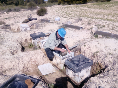 |
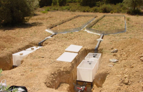
| Picture 2.2.10.1 Bounded (left) and unbounded Gerlach-type (right) erosion plots connected to sediments and runoff collecting tanks in two study sites in Murcia (SE Spain). Photo: María Martínez-Mena (left) and Eloisa García (right) | |
After each erosion event, runoff and soil loss is measured by collecting the water and sediments from the storage tanks connected to the bounded or unbounded runoff plots. Sampling of the sediments from the tanks is carried out after thorough stirring taking a minimum of five aliquots of a known volume (e.g. 1 L) from different depths using plastic bottles. Along with the runoff erosion plots, a recording rain gauge in the experimental area is desirable to measure precipitation after each event.
Both sediment and water samples should be ideally stored in a portable fridge at 4 °C during their transport from field to laboratory. Later in the laboratory, the sediment collected in the sediment traps and the runoff are analysed for total suspended solids (TSS), organic carbon, and nutrients. Ideally, samples should be processed immediately after collection, but if not possible, samples should be stored at 4 °C for short periods or frozen (-20 °C) for long periods. Annual losses by erosion (in g m-2 yr-1) are calculated as the sum of the concentration of each parameter (TSS, carbon, nutrients) measured in each erosion event during one year, divided by the surface of the bounded plots or by the known contributing drainage area of each sediment trap (that can be estimated from a Digital Terrain Model with a certain resolution).
- b) Measurements of erosion processes occurring at larger spatial scales (i.e. slope and catchment)
Measurements of erosion processes at larger spatial scales such as gully erosion and mass movements can also be monitored in the field. A simple method of estimating cumulative volume of soil removed by rill or gully erosion on a slope is to determine the cross-sectional area of the rills/gullies along a series of transects of 20–100 m long across the slope (see Stocking & Murnaghan (2001) and Morgan (2005) for details on the protocols). The bulk density (see protocol 1.3 Soil type and physical characteristics) of the removed soil is then needed to estimate the sediment losses by weight. A similar approach can be used to estimate the volume and weight of sediments recently deposited on hillslopes or at footslopes, measuring their length, width, depth, and bulk density.
For mass movements (bank erosion, landslides) soil erosion can be estimated using tracers either for the short- (7Be) or long-term (137Cs and 14C). The use of these radioactive isotope tracers in soil profiles can provide not only qualitative information on the patterns of soil erosion/deposition in a landscape over time depending on the decay rate of the isotope, but also estimates of soil erosion rates when combined with conversion models such as the proportional approach or the mass balance model (Morgan, 2005).
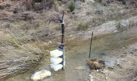
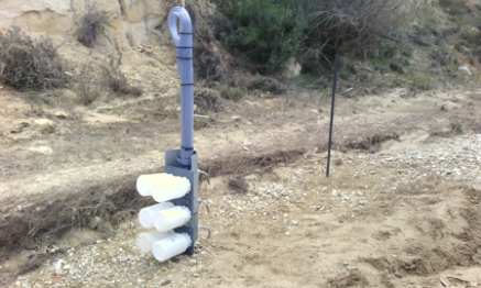
At the catchment scale, given the episodic nature of water erosion processes, continuous and long-term monitoring of sediment fluxes is desirable. However, these more integrative measurements are costly and time-consuming, and hence mostly focus on measurements at the catchment outlet. In this regard, an inexpensive and reliable means of automatically collecting water samples for suspended-sediment measurements in ephemeral channels and headwater streams is the siphon sampler (Diehl, 2008). Multiple samplers are spaced vertically to collect suspended-sediments samples at different depths (Picture 2.2.10.2). Each sampler includes a sample container (typically a 0.5 or 1 L bottle), an intake tube, and an air vent. The siphon samplers are useful when multiple and/or remote sites need to be sampled. However, some limitations of this sampler are that the time at which the sample is taken is unknown, the stage at which sampling begins depends on the intake orientation and on the stream velocity and turbulence, and the sand concentration contained in the sampler can be higher or lower than that of the stream. It is very important to select an appropriate location to install the sampler to get a representative sample without compromising its functionality. For example, if the sampler is installed in the main channel it can be exposed to debris impact and accumulation as well as strong hydraulic forces that can affect representativeness of the sample. For more details on pros and cons and on how to build a siphon sampler see Diehl (2008).
 |
 |
|
Picture 2.2.10.2 Siphon samplers placed in an intermittent (left) and ephemeral (right) stream in a semi-arid catchment in Murcia (SE Spain). Multiple samplers are spaced vertically to collect suspended-sediments samples at different depths during a flooding event. Photo: María Almagro. |
|
Where to start
Boardman & Poesen (2007), Diehl (2008), Hudson (1993), Lal (1994), Morgan (2005), Stocking & Murnaghan (2001), Wischmeier & Smith (1978)
2.2.10.2 Special cases, emerging issues, and challenges
Although this protocol focuses on direct field measurements of soil water erosion at different spatial scales, including different forms and types of erosion plots, morphological transects, and siphon samplers, there are many other direct methods such as erosion pins, quantification with 137Cs, experimental catchments, and bathymetrical surveys of reservoirs, as well as several indirect methods to monitor runoff and soil erosion, such as modelling, remote sensing and GIS analysis, and estimation with topographic benchmarks related to vegetation, dendrochronology, and digital elevation model (DEM) reconstruction. For more details, see Cantón et al. (2011) and Doetterl et al. (2016).
Emerging approaches to obtain the spatial distribution of soil erosion and deposition processes consist of large-scale terrestrial and aerial monitoring using drones and digital photogrammetry (Hackney & Clayton, 2015).
2.2.10.3 References
Theory, significance, and large datasets
Boardman (2006), Boardman & Poesen (2007), Boix-Fayos et al. (2006, 2007), Maetens et al. (2012), Quinton et al. (2010), Renschler & Harbor (2002), van Oost et al. (2007), Vanmaercke et al. (2011, 2012), de Vente & Poesen (2005)
More on methods and existing protocols
Doetterl et al. (2016), European Commission (2006), Iserloh et al. (2013), Hackney and Clayton (2015)
All references
Almagro, M., & Martínez-Mena, M. (2014). Litter decomposition rates of green manure as affected by soil erosion, transport and deposition processes, and the implications for the soil carbon balance of a rainfed olive grove under a dry Mediterranean climate. Agriculture, Ecosystems & Environment, 196, 167-177.
Boardman, J. (2006). Soil erosion science: Reflections on the limitations of current approaches. Catena, 68(2-3), 73-86.
Boardman, J., & Poesen, J. (Eds.). (2007). Soil Erosion in Europe. John Wiley & Sons.
Boix-Fayos, C., Martínez-Mena, M., Arnau-Rosalén, E., Calvo-Cases, A., Castillo, V., & Albaladejo, J. (2006). Measuring soil erosion by field plots: understanding the sources of variation. Earth-Science Reviews, 78 (3-4), 267-285.
Boix‐Fayos, C., Martínez‐Mena, M., Calvo‐Cases, A., Arnau‐Rosalén, E., Albaladejo, J., & Castillo, V. (2007). Causes and underlying processes of measurement variability in field erosion plots in Mediterranean conditions. Earth Surface Processes and Landforms, 32(1), 85-101
Cantón, Y., Solé-Benet, A., de Vente, J., Boix-Fayos, C., Calvo-Cases, A., Asensio, C., & Puigdefábregas, J. (2011). A review of runoff generation and soil erosion across scales in semi-arid south-eastern Spain. Journal of Arid Environments, 75(12), 1254-1261.
de Vente, J., & Poesen, J. (2005). Predicting soil erosion and sediment yield at the basin scale: scale issues and semi-quantitative models. Earth-Science Reviews, 71(1), 95-125.
Diehl, T. H. (2008). A modified siphon sampler for shallow water (No. 2007-5282). US Geological Survey.
Doetterl, S., Berhe, A. A., Nadeu, E., Wang, Z., Sommer, M., & Fiener, P. (2016). Erosion, deposition and soil carbon: A review of process-level controls, experimental tools and models to address C cycling in dynamic landscapes. Earth-Science Reviews, 154, 102–122.
European Commission. (2006). Proposal for a directive of the European Parliament and the council establishing a framework for the protection of soil amending directive 2004/35/EC. Commission of the European communities. Retrieved from http://eur-lex.europa.eu/legal-content/EN/TXT/PDF/?uri=CELEX:52006PC0232&from=EN
Hackney, C., & Clayton, A. I. (2015), Section 1.7: Unmanned aerial vehicles (UAVs) and their application in geomorphic mapping: Geomorphological techniques. In L. E. Clarke, & J. M. Nield (Eds.), Geomorphological Techniques (online edition; pp. 1-12). London: British Society for Geomorphology.
Hudson, N.W. (1993). Field measurement of soil erosion and runoff. FAO Soils Bulletin, 68.
Iserloh, T., Ries, J., Arnáez, J., Boix-Fayos, C., Butzen, V., Cerdà, A., … Wirtz, S. (2013). European small portable rainfall simulators: A comparison of rainfall characteristics. Catena, 110, 100-112.
Lal, R. (1994). Soil Erosion Research Methods. Boca Raton: CRC Press.
Lal, R. (2005). Soil erosion and carbon dynamics. Soil and Tillage Research, 81(2), 137-142.
Maetens, W., Poesen, J., & Vanmaercke, M. (2012). How effective are soil conservation techniques in reducing plot runoff and soil loss in Europe and the Mediterranean? Earth-Science Reviews, 115(1-2), 21-36.
Montgomery, D. R. (2007). Soil erosion and agricultural sustainability. Proceedings of the National Academy of Sciences USA, 104(33), 13268-13272.
Morgan, R. P. C. (2005). Soil Erosion and Conservation. Oxford: Blackwell Publishing
Quinton, J. N., Govers, G., van Oost, K., & Bardgett, R. D. (2010). The impact of agricultural soil erosion on biogeochemical cycling. Nature Geoscience, 3(5), 311.
Renschler, C. S., & Harbor, J. (2002). Soil erosion assessment tools from point to regional scales—the role of geomorphologists in land management research and implementation. Geomorphology, 47(2-4), 189-209.
Stocking, M., & Murnaghan, N. (2001). Handbook for the Field Assessment of Land Degradation. Earthscan.
Throop, H. L., & Archer, S. R. (2009). Resolving the dryland decomposition conundrum: some new perspectives on potential drivers. In U. Lüttge, W. Beyschlag, B. Büdel, & D. Francis (Eds.), Progress in Botany (vol. 70; pp. 171-194). Berlin: Springer.
van Oost, K., Quine, T. A., Govers, G., De Gryze, S., Six, J., Harden, J. W., … Giraldez, J. V. (2007). The impact of agricultural soil erosion on the global carbon cycle. Science, 318(5850), 626-629.
Vanmaercke, M., Poesen, J., Verstraeten, G., de Vente, J., & Ocakoglu, F. (2011). Sediment yield in Europe: Spatial patterns and scale dependency. Geomorphology, 130(3-4), 142-161.
Vanmaercke, M., Poesen, J., Radoane, M., Govers, G., Ocakoglu, F., & Arabkhedri, M. (2012). How long should we measure? An exploration of factors controlling the inter-annual variation of catchment sediment yield. Journal of Soils and Sediments, 12(4), 603-619.
Verheijen, F. G. A., Jones, R. J. A., Rickson, R. J., & Smith, C. J. (2009). Tolerable versus actual soil erosion rates in Europe. Earth-Science Reviews, 94(1–4), 23–38.
Wischmeier, W.H., & Smith, D.D. (1978). Predicting Rainfall Erosion Losses. USDA Agricultural Research Service Handbook 537.
Authors: Almagro M1, Abrantes N2
Reviewers: Keizer JJ2
Affiliations
1 BC3-Basque Centre for Climate Change, University of the Basque Country, Leioa, Spain
2 Earth surface processes team, Centre for Environmental and Marine Studies (CESAM), Department of Environment and Planning, University of Aveiro, Aveiro, Portugal